
About Me
I am Tang Kai (唐凯), a Ph.D. candidate in Cartography and Geographic Information Systems at Beijing Normal University (2022.09-2026.06), advised by Prof. Jin Chen. My research focuses on remote sensing image processing and applications, change detection, on-orbit computing, and artificial intelligence for Earth observation.
My research experience began with Remote Sensing Science and Technology during my undergraduate study, followed by master's research on radiometric quality improvement and physical parameter retrieval for China's Fengyun meteorological satellites. During my Ph.D. study, I have focused on deep learning-based change detection and multimodal data fusion, with an emphasis on integrating remote sensing physics and geoscientific knowledge into AI models.
I am always open to collaboration and academic exchange with researchers and practitioners interested in remote sensing, GeoAI, change detection, agricultural intelligence, data fusion, and Earth observation applications.
Research Interests
- Change detection: high-resolution single/bi-temporal change detection, medium-resolution time-series change detection, and near-real-time anomaly discovery.
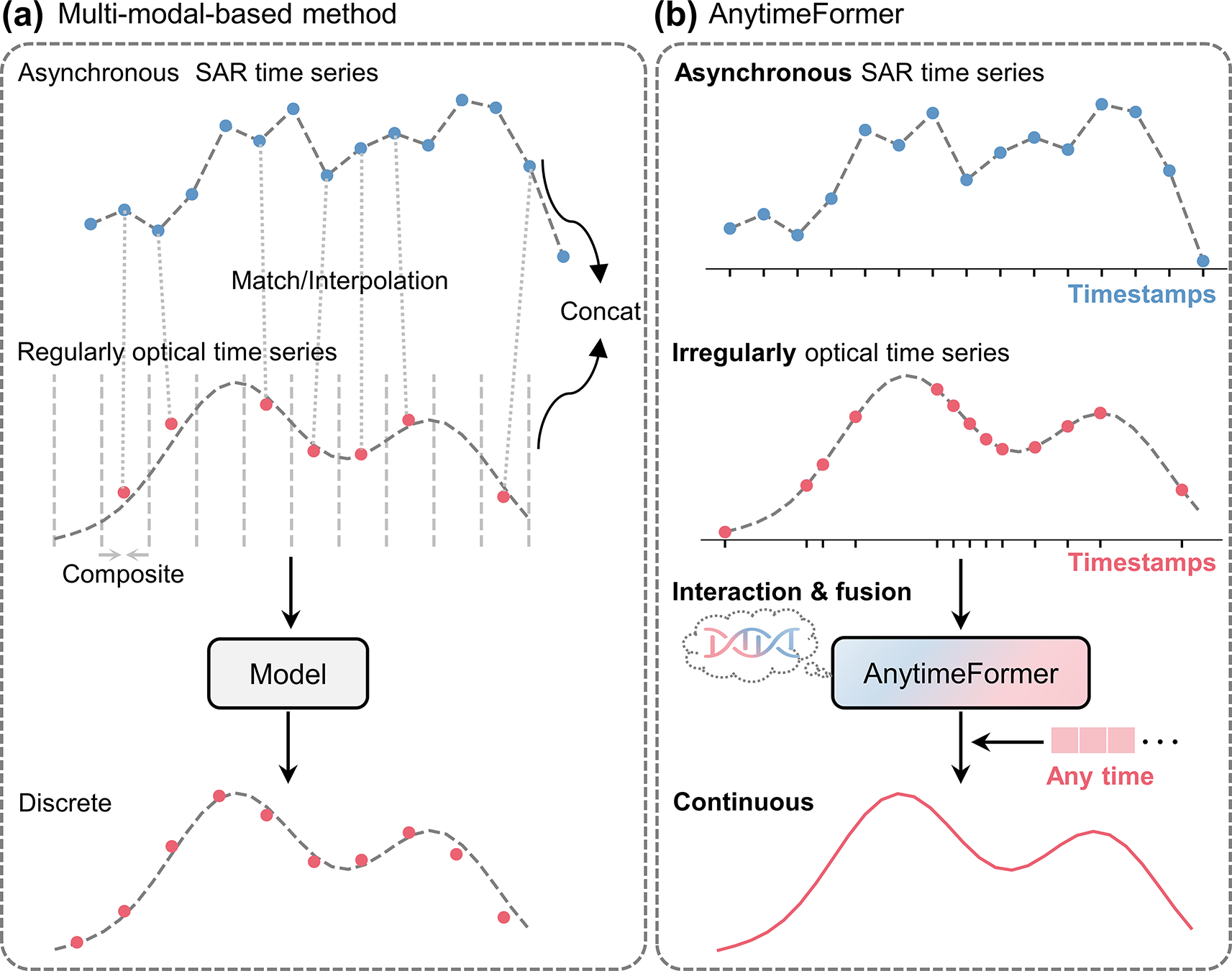
- Data fusion: optical-SAR fusion, asynchronous time-series reconstruction, and multimodal Earth observation learning.
- Agricultural remote sensing: crop mapping, sowing and harvest date detection, yield estimation.
News
- 2026.05 Received the titles of Outstanding Graduate of Beijing Municipality and Outstanding Graduate of Beijing Normal University.
- 2026.03 A Paper on estimation of crop sowing dates was accepted by The Crop Journal (JCR Q1 TOP).
- 2026.03 ClearSCD has been selected as an ESI Highly Cited Paper.
- 2026.02 A Paper on crop mapping models was accepted by ISPRS Journal of Photogrammetry and Remote Sensing and released with [Code].
- 2026.01 DreamCD was accepted by International Journal of Applied Earth Observation and Geoinformation and released with [Code] and [Dataset].
- 2026.01 Shield was accepted by Journal of Remote Sensing and released with [Code].
Selected Publications
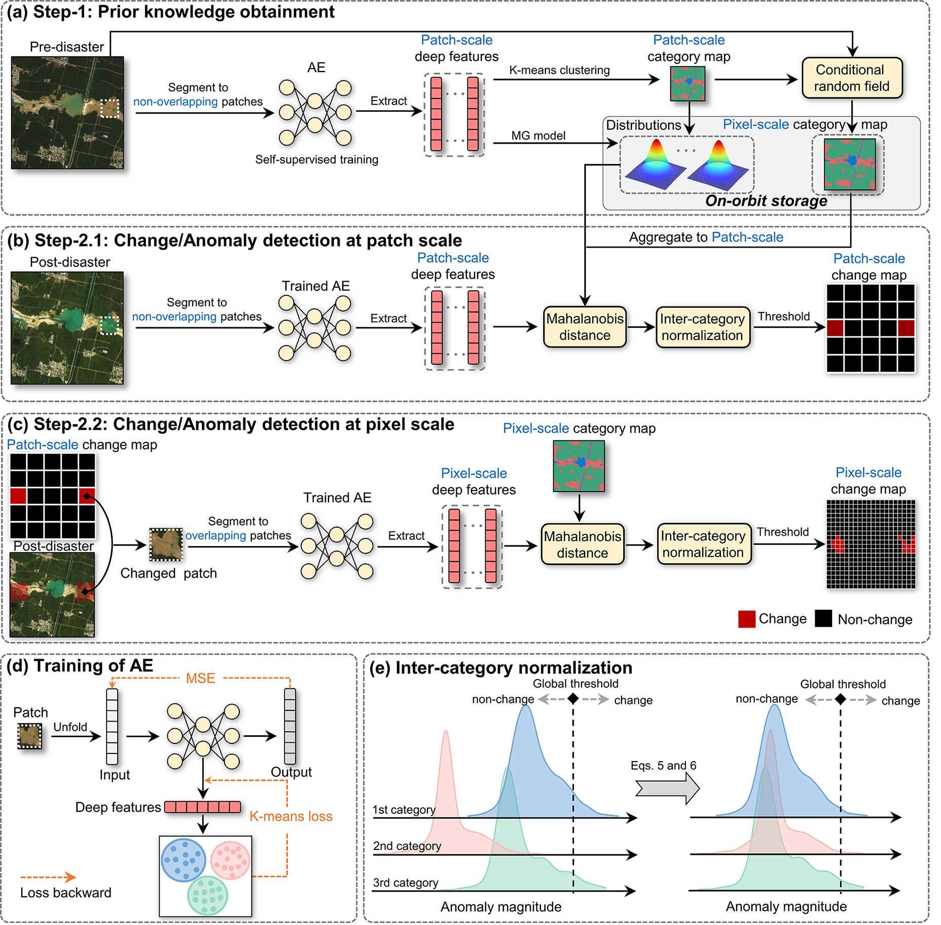
Unsupervised detection of disaster-affected areas by combining the strengths of change detection and anomaly detection: target for on-orbit application.
Journal of Remote Sensing, 2026.
Kai Tang, Qiao Wang, Fei Xu, Zhuoning Gu, Xuehong Chen, Jin Chen†
[Paper] [Code]
A lightweight framework designed for real-time disaster analysis and on-orbit deployment.
Education
- 2022.09-2026.06 Ph.D. in Cartography and Geographic Information Systems, Beijing Normal University.
- 2019.09-2022.06 M.Eng. in Surveying and Mapping Engineering, Shandong University of Science and Technology.
- 2015.09-2019.06 B.Eng. in Remote Sensing Science and Technology, Shandong Agricultural University.
Honors and Awards
- 2026.05 Outstanding Graduate of Beijing Municipality.
- 2026.05 Outstanding Graduate of Beijing Normal University.
- 2025.01 Academic Innovation Award, Beijing Normal University.
- 2023.11 First Prize, Graduate Academic Competition, Faculty of Geographical Science, Beijing Normal University.
- 2022.05 Outstanding Graduate of Shandong Province.
- 2021.10 National Graduate Scholarship.
Academic Services
- Reviewer for Remote Sensing of Environment, ISPRS Journal of Photogrammetry and Remote Sensing, IEEE Transactions on Geoscience and Remote Sensing, International Journal of Applied Earth Observation and Geoinformation, International Digital Earth, Ecosystem Health and Sustainability, and Journal of Remote Sensing.
Contact
- Email: tangkai@mail.bnu.edu.cn
- Alternate email: a1362723810@gmail.com